Category Archives: Geocaching

Our Gnome holidays in the US ….

One of our entries in the Geocaching Australia GeGnome Project, Firesafe Hoe, has made it to the US.

He started his journey in Port Lincoln and in a couple of days I received an email saying that it was in Melbourne and was looking to get on a jet plane to the US.

His first stop was Los Angeles and within viewing distance of the happiest place on Earth, Disneyland.

After a couple of days it was then onto Graceland in Memphis Tennessee. Elvis had left the building so no sense staying there.

He is now sunning himself in Orlando Florida after travelling 17340 kms.

Where to next??

His progress can be followed at the GeGnome Project Ladder.

December 12 of 12 – nearly forgot …

If it hadn’t been for a tweat from Mundoo, I would have forgotten that today was the 12th of the month.

Today was a cruisy sort of day. Had to drop off Bradley at a friends house at Flagstaff Hill. This gave me a chance to grab a couple of caches and at the same time hide a Gnome from the GeGnome Project. The GeGnome Project is a Geocaching Australia caching game where 217 garden gnomes have been hidden around Australia and for the months of December and January get moved around by geocachers.

One of the Gnomes (Firesafe Hoe) I have hidden has travelled so far from Port Lincoln to Melbourne to Los Angeles to Memphis so is leading the ladder for distance. I hope he makes it back to Australia.

I have been out of action walking wise for a couple of weeks now due to a bad case of gout. Yes I have heard it all – getting old, drinking too much, etc., etc. It may be the old bit but not the drinking bit as I have been on call most of the last two weeks.

Today was the first day I have felt like walking so I decided to go for a walk in the Sturt Gorge Recreation Park to grab a cache – Marri Track.

Back home and the deck is now finished around the pool so I had the pool fence to go back up. I was ably supervised by our dog, Molly, although I think she was more interested in the birds and other dogs making noise around the neighbourhood.

Yesterday I attended a Pathtag Swap Meet which meant that I had about 50 pathtags to log today as well.

BBQ with family friends for tea, then once it got dark, time for our Xmas lights to spring to life. We then dropped Bradley off at his friends for a sleepover and took the girls Xmas Light spotting. The most impressive ones were behind the BP at O’Halloran Hill.

So ends the 12 of 12 for December. 🙂

The GeGnome Project has begun ….

The game runs from 01-Dec-2010 00:00:00 to 31-Jan-2011 23:59:59.

This game requires hiding a moving cache on Geocaching Australia. Specifically the geocache must be a garden gnome.

Yes, a real garden gnome. Not a plastic box you call a garden gnome, a genuine, real life, garden gnome.

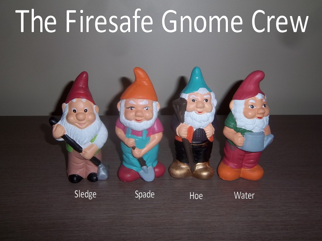
We have entered 4 Gnomes in this Game. They are:

Firesafe Water

Firesafe Hoe

Firesafe Sledge

Firesafe Spade

Two are starting out in Port Lincoln and two are starting off in the Adelaide Hills. It will be interesting to see where they end up over the next 2 months.

Their progress can be followed at the GeGnome Project Ladder.


A week in Port Lincoln …

One of our Regional Fire Stations is in Port Lincoln which has just been replaced with a new station. The new station is an impressive show-piece for the Metropolitan Fire Service and forms part of the Emergency Services Precinct where the Country Fire Service and State Emergency Service have also had new stations built.

I had the opportunity to spend a few days in Port Lincoln. The trip was to exercise the Regional Staff at the new station and integrate operations with the CFS for an notional wildfire occuring in our area then a second wildfire starting in our area then escaping into CFS area.

The exercise was on the Wednesday but I flew in a couple of days earlier to ensure that the crew were all familiar with the equipment and processes that are used by the MFS and CFS. The exercise went well with lessons learned by both the MFS and CFS personnel and hopefully the SAPOL Officers as well.

Even though it was a work trip, there was time after hours to get some caching in as well. There is a very active geocaching community in Port Lincoln with around 150 caches hidden around the town. In the 4 days I was there I managed to find 42 of them.

October 2010 – 12 of 12 ….

After having 10 days off to travel across to the West Coast, up the Googs Track, then up to the Northern Territory Border, across to Finke and then down the Oodnadatta Track to the Flinders (4200 km) it was hard to have to go back to work today.

Today wasn’t going to be anything special but it took a lot longer today to get to work with the Freeway shut down due to a truck crash and a water main burst on Fullarton Road shutting down most roads into the City.

After clearing out the backlog of emails, I was asked to attend some eProcurement training at Westpac House. At least the walk got me out of the office.

Took some photos of the two building projects. The car park to the north is now complete and the Police HQ behind the Fire Station is still heading upward.

Even though I am the keeper of the On-Call Roster, I still have to do my bit and this week coming is my time. This means being on-call 24/7 for a week and attending any 2nd Alarm incidents in the Metropolitan area (80km x 25km). Grabbed my turnout gear from the dry cleaning locker and I am now ready to go.

Tomorrow I am off to Port Lincoln to do some groundwork for an Operational Exercise to be held in November, so of course I checked to see where all the caches are in case I get some downtime during the day.

Then back home with still traffic chaos due to the Freeway still shut down due to the truck accident – there was a fatality so it may be shut for a while.

Finished up with Molly as always waiting patiently for any scraps that may “fall” from the table during tea.

The Oodnadatta Track

We were awoken this morning by the sound of rain on canvas and we were not sure how much more was to come so it was a mad scramble to break camp and head south to Oodnadatta.

The rain didn’t let up but it wasn’t heavy, just persistent. With that the road was quickly turned to mud which slowed us down.

Because we had to break camp before getting breakfast, we stopped at Pinks Roadhouse after the 50km journey which took about an hour, refuelled (ended up having plenty of fuel due to dry conditions yesterday) and had breakfast at the roadhouse. It must have been mail day as most of the population headed through collecting their mail while we were there.

Given the conditions of the day, it was interesting to see the road conditions still indicating the Track was open to 2WD cars. The track was now getting very muddy and very slippery.

We made a stop at the Algebuckina Bridge which is the longest rail bridge in South Australia but of course is not used any more now that the Ghan railway has been moved over towards the Stuart Highway. The going around here was getting hard with an inch of mud added to your shoes as we walked around. We had a little reprieve and a chance to wash some mud off on the new concrete causeway over the Neale River.

It wasn’t long before we came across a German on a motorbike basically walking the bike as he kept falling over in the mud. He had handed his gear to another traveller to take to William Creek. I don’t think he was going to catch up with that for a while as there was about 100 km to go until then. Another 5km on and we came across 2 double road trains full of cattle bogged on the track. It was interesting trying to get around them without sliding into the sides of the trucks. These guys were going to sit it out until the road dried up – could be a day or two.

More drama a little further on when The Parrots went over a crest and lost it, starting to head off into the prairie and starting to roll but stopped before heading over. I came over the crest not that quick but still had issues pulling it up before getting to them. I managed to stop with about 10m to spare. Phew!!

We both had another lose on the last 500m into William Creek. At this stage the Road Condition sign had changed from “Open” to “4WD” but I would say it wouldn’t be long before it became “Closed”. It was time to fuel up and have a well deserved beer at the William Creek Hotel.

Our cars soon became talking points with others wanting to know where we had come from and the conditions that way. After talking with us a lot of people decided to camp the night at William Creek and hope that the Oodnadatta Track would dry out by morning.

After a bit of a break and looking at the relatively clean cars coming from the south we decided to continue south down the track to Coward Springs and have a soak in the Hot Pool and camp there.

Hooray, we actually arrived somewhere in daylight. After setting up camp in a great location (or so we thought), it was off to a soak in the Hot Tub. After Dalhousie Springs, this one was very bearable and was more towards tepid than hot.

With a spectacular sunset, it was time for some eats and drinks around the campfire before heading off to bed.

Around 11:30pm the wind sprung up from the desert and we soon found out that our ideal campsite had little protection from the desert. Being in the roof tent it was easy for me to uproot camp and move to another location with some wind shelter. The Parrots however had to use their car as a shield and weather it out as best they could. In the end some damage was sustained to their new tent.

Dalhousie Springs …

The bugs and the rain had gone when we awoke this morning. The only issue now was fuel to get to Oodnadatta. I was on empty but had filled the jerry cans back at Coober Pedy – that gave me about 35 to 40 litres. Parrots were about the same. Mt Dare had said that we would need about 60 litres in the current conditions to make it.

Their solution was to drain the sub tank of their Landcruiser which held 100 litres, of which we were welcome to 20 litres each at a cost of $2 a litre – who was going to complain about the price out here. As it was, we nearly missed out as some other travellers heard about this and were going to grab the lot and they were only going the 100 km to Finke. Lucky we had teed it up last night and we got our 20 litres each.

It is amazing how quickly the roads dry out as apart from the roads nearest Mt Dare, the rest were heading back to dust. With buoyed enthusiasm, and 3/4 of a tank of fuel, we decided we would make the diversion to Dalhousie Springs and stay the night there. It only added an additional 5km to the journey.

The trip was uneventful and we made good time arriving around lunch time. Andrew and I headed off for a walk to grab a couple of caches including another Astro cache. After the walk it was time for a soak in the Springs. Having spent time in other springs such as Mataranka, I was looking forward to this.

What we didn’t know was how hot it was. The temperature of the water was up around 40 degrees so you could only stay in for about 15 minutes before needing to get out to rehydrate and cool. Did this couple of times, chatted with some others that had just made the journey through the Simpson Desert.

The mozzies were starting to get friendly so we decided to keep moving south towards the Oodnadatta Track via the Public Access Route #8, passing the Dalhousie Ruins on the way. Again we past through some amazing country, then arriving at Hamilton Station we came onto a new road that went for about 30km. It was better than the Stuart Highway – it is amazing how money talks (obviously had been built for Hamilton Station).

Once again we were heading towards sunset so it was time to find a spot to camp. We came across Alberga River and a familiar voice on the CB. It was one of the vehicles from the Goyder Creek crossing the day before. He was bogged in the river sand. We headed in and helped him out then found an area that was above where water may come through during the night. There was no clouds in the sky but with the weather patterns they way they were, we were not prepared to take any chances of a flash flood. We also camped on the southern side of the river in case it did become impassable.

Unfortunately we failed again to have our evening meal in daylight – maybe tomorrow.

Northern Territory here we come …

There was no rain in Coober Pedy when we awoke but there was certainly plenty to the East. After a shower and breakfast, it was time to grab a few geocaches before heading north to the Northern Territory border. There was a few drops of rain on the windscreen on the trip north but it was actually cold and had to put the heat on, that is until we hit Kulgera. The traffic had been light but when we got to the Border, there was vehicles everywhere. Refuelled at Kulgera and it was summer again with temps in the low 30’s.

We travelled east towards Finke and the roads were dusty and the temps warm but the closer we got towards Finke, the darker the clouds and the stronger the winds. A quick stop at Lamberts Gravitational Centre Monument which is supposed to be the gravitational centre of Australia.

We did a drive-by of Finke and probably should have fuelled up but were a little late for the General Store as it was all boarded up after closing time.

As we left Finke, it wasn’t long before the roads turned from dust to mud and the bottom of each dip was a flowing creek. My travelling partners were getting a little apprehensive but I convinced them to continue. As we came over one rise 10 km south, we were greeted by a group of travellers and the flowing Goyder Creek (150 metres wide). Was this going to be the end of the journey south.

The others had been there for 30 minutes and in that time the creek had receded 6 metres. The wait was on and with some of the group walking the road, a track was worked out through the water and all waited while the first vehicle headed across. He got over OK and the rest of us followed.

After getting across this creek, we were then presented with 25 km of mud and water across the road. The going was slow with some spots having to be walked first before proceeding but after an hour or so we came across dust again.

By the time sunset came, we were at the South Australian / Northern Territory Border again but no problem with traffic here except for cattle roaming.

My travelling companions headed to Mt Dare from here and I continued south along the Ghan line to grab some caches before meeting up at Mt Dare in an hour or two – or so was the plan.

All was going well, arriving at dusk at Abminga Ruins then arriving at Eringa Waterhole in the dark. Headed back out the road I came then off east on the Mt Dare Road but didn’t get too far before “disaster” struck. I was coming around a corner at around 80 kph when there was a creek crossing with mud rather than water. I slowed up and feathered the brakes but unfortunately something gripped and I found myself heading off into the scrub on 2 wheels and starting to tip over. I managed to wrestle it back onto 4 wheels before going over but not before popping a tyre off the rim.

A quick check of the car to check for other damage then rang through to Mt Dare to let the Parrots know not to expect me for a while as I had some work to do. After getting the spare wheel off, jacking up the car and taking off the “popped” wheel about 20 minutes had transpired. It was interesting watching the various insects making their way to the light from my car.

Had a look at the tyre and there appeared to be no damage apart from a lack of air so connected up the compressor and it popped back onto the rim and stayed up so back on the car it went. Put the spare back on its home, car off the jack and 35 minutes later and a bit of mud, I was on my way again to Mt Dare.

The road was getting muddier and there were a number of lakes where the roads should have been so after some off road driving, I eventually made it to Mt Dare, albeit a little later than planned. The Parrots were in the bar having a lager or two waiting for me. The staff got me a pie and beer for tea – it was 10:00 pm after all. A last downer for the day – the fuel truck hadn’t been able to get through for 3 weeks and they were out of unleaded fuel and we didn’t have enough to get through to Oodnadatta. That will be tomorrows challenge.

We went down to the camping area and the first thing we found was the insects and mosquitoes hanging out with us. So after a quick shower it was to bed. It had been a big and different day today.

Mt Finke and beyond …

Finally a chance to get some 4WDing in. Googs Track north from Googs Lake was certainly more challenging than the track south. The sand was a little deeper and the dunes a little higher and steeper. As Adrian Mac was to find out, having the right tyre pressure made all the difference when heading over these dunes.

The morning was spent going up and down sand dunes through some dense scrub. It is amazing the difference a bit of rain makes in these areas. Our goal this morning was to get to Mt Finke and climb to the top. Mt Finke is the tallest thing around these parts and sits at 369m (not high as far as mountains go).

We arrived around lunch time and soon a group of us were making our way to the top after finding an Astro Geocache on the way up. With the way the rock was laid down, it was like climbing a large staircase to get to the top.

After working up a sweat on the way up, a few photos at the top and some phone coverage (quick phone call home), it came a little unstuck on the way down. As I was heading down, a rock I was on gave way and down I started tumbling, only being able to stop by grabbing some Porcupine Grass (and that hurts). Sustained some collateral damage including skin off from the knee down, damage to my ankle (swollen and tender) and numerous pin pricks to the hands. Made it down to the bottom, a quick wash off, some iodine and we were on our way again towards Tarcoola.

After crossing the Trans-Australian Railway, it was onto Tarcoola. This town used to be a booming town with the railways and mining nearby, but now there is only one person living here and is a railway lay over area where two trains can pass on the single rail line. It just happened that there was a train parked and waiting with another coming the other way when we arrived. We couldn’t have timed it better.

After a brief look around town, we headed east towards Glendambo through Kingoonya. In contrast to Tarcoola, Kingoonya was rocking with the pub full of people. This seems to be the place of choice for the locals and those in the know as it is not full of the tourists you find in Glendambo.

The final stop as a group was at Glendambo. Here 5 of the vehicles headed south and 4 including me headed north. Before splitting up a photo was taken of the assemblage and birthday treats for one of the kids of Tony Mashford were handed out to all. The lolly bag even had a pathtag inside.

The northern group were headed to Coober Pedy for the night. We were entertained by a lightning show and a motorbike sat on my tail most of the way. I don’t think he wanted to come head to head with any wildlife on the way and was happy to use me as a wind and wildlife break.

We camped the night at Stuart Range Caravan Park which also had a Pizza Bar inside so it was beer and pizza at 10:30pm. There was a little bit of rain over night but not as much as what was to come.

Onto Googs Lake ….

We awoke this morning to some dark clouds to the north. What a contrast to the 2 great days we had just had. It could be a wet day ahead. After breaking up camp, we headed towards Ceduna via Smoky Bay with some drizzle but not heavy rain. The dirt roads were a little slippery.

Once we hit Ceduna, it was still overcast but the darker clouds seemed to have moved on. After grabbing a few caches and doing some refuelling and restocking, it was time to get to the start point. This is the first time that all vehicles had got together and after the attachment of sand flags it was time to get going.

There was some light rain as we entered the Yumbarra Conservation Park but it was fairly easy going to Googs Lake, with only a couple of sandhills providing a challenge to a 2WD vehicle. In fact there was no need to engage 4WD on this section.

Arriving at Googs Lake, we needed to get some 4WDing in and there was a couple of tracks up from the lake that challenged a few of us but all got up in the end.

Giving the Fronty a workout

Another hill for the Fronty …

A stop for lunch then it was off to Nalara Rock & Lois Rock. This involved a 100km round trip on some rugged tracks but only due to corrugations. Once there, these were impressive rocks with some great views of the area. There were even rock pools with tadpoles after the recent rains.

Back to Googs Lake, set up the campsite and time for some campfire stories and beverages until the early hours.

With regard to the mouse plague. At this time we have seen nothing that even looks like a mouse so the stories may have been over exagerated.